Baltimore County redistricting commission narrowly approves new 9-district map
Natalie Jones
The Baltimore Sun
June 10, 2025
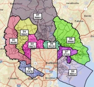
Baltimore County’s redistricting commission settled on a final councilmanic district map Monday night following a difficult monthslong process to create nine new council districts.
The map approved by the commission creates two majority Black districts on the western side of the county, along with two districts made up of racial and ethnic minorities on the eastern and western sides of the county. The remaining five would be white-majority districts.
The 2-2-5 plan was first introduced on Thursday by commission member Michelle Davis, who lives in Windsor Mill and represents the existing District 1. Davis said she knew it wasn’t what some had hoped for, but expanding the Baltimore County Council from seven to nine districts wouldn’t come without sacrifice.
“While, again, District 1 doesn’t look like that which many people were expecting it, I believe that we all had to give consideration, to give it a little in order to get a little, with the fact in mind that … our councilmen have the final say in all of this,” she said.
The commission approved the map in a 4-3 vote, with members Cordell Grant, John Dulina and Ed Kramer voting against it.
The approval comes days after an emotionally charged meeting where several members spoke about pressure and threats from the community to consider or adopt certain maps. Tasked with drawing nine new councilmanic districts, the commission reviewed hundreds of comments from residents on the eastern and western sides of the county, which made coming to a consensus an arduous process, members said.
The commission knew not everyone would be pleased with the final map. Lisa Belcastro, a Pikesville resident who represents existing District 2, described what was ultimately approved as the “culmination of the advocacy” surrounding all of the maps the commission received.
“This is a best attempt to try and address as much of the concerns as possible,” she said. “Obviously, I think we’ve all said as a commission not everyone is going to be happy, not everyone is going to get what they want, and that’s impossible. But I feel like this is a map that we can be proud of that strikes that balance of putting the Voting Rights Act at the forefront, but also having that due regard for communities.”
Kramer, a Middle River resident who represents the current District 7, said from the outset of Monday’s meeting that he would not approve any map. He told The Baltimore Sun that the final map was “quite disappointing,” but the process isn’t over yet.
“The Essex, Middle River, Dundalk, waterfront communities — we’ve always worked together, and this right here, this map, splits us up,” he said. “We’ll see how things go, but I’m hoping the council is going to make some changes in regards to that.”
A councilmanic redistricting map needs five affirmative votes from the council to be adopted, according to the county charter. That may not be possible, however.
“The Republican Councilmembers stand united against the partisan map advanced by this commission,” Councilmen Todd Crandell, David Marks and Wade Kach said in a joint statement issued after the meeting. “No map will pass without Republican support.”
“It’s dead on arrival,” Marks, an Upper Falls Republican who represents the existing District 5, said in a phone interview.
The council will consider the commission-recommended map in the coming months. It must adopt a final redistricting plan by Oct. 1.
Sharonda Huffman, who lives in eastern Baltimore County and is running for Baltimore County Council in 2026, had backed a map that would have created three majority-Black districts on the west side of the county, one majority district made up of racial and ethnic minorities on the east side, and five majority-white districts. While the final approved map wasn’t exactly what she had hoped it would look like, Huffman said she was happy with it.
“3-1-5 is the goal, right? Reality is, you shoot for the stars and you get the moon,” she said. “I just wanted to make sure we had a BIPOC district, and I wanted to make sure there was enough opportunity for minorities to choose candidates of their choice. I think the 2-2 is fine.”
Supporters of the Woodlawn Approach, a map created by Keith Dorsey, Baltimore County’s former budget chief, were more disappointed by the map the commission approved.
Dorsey’s map, which had been tweaked several times over the past few months, would have created two supermajority-Black districts on the western side of the county and another made up of racial and ethnic minorities.
Grant, an Owings Mills resident who represents the existing District 4 on the commission, supported the Woodlawn approach, saying it was compact, politically cohesive and amendable. It was the most legally sound map, he said.
“The Woodlawn map is not trying to ensure extra power for the Black and brown voters, or the Black and brown communities, or the Black and marginalized communities,” Grant said. “It is about being heard fairly, and I think that it creates a great foundation.”
Dorsey highlighted the flexibility of his map, which he had modified to keep certain communities together.
“The proof will be in the pudding a year and a half from now if in fact we have no increase in African American representation on the Council, or even the loss of the one we have,” Dorsey said after Monday’s meeting.
The map will be officially released with a report from the commission sometime next week.